
Motivation
|
Predictive models are required that enable assessments of wind erosion and dust emission to be conducted across land use and land cover types and in response to different land management. The National Wind Erosion Research Network will generate data to improve existing models, develop new approaches to representing management impacts, and provide a means for quantifying model performance and uncertainty across application areas. |
 Field measurements of aeolian (wind) sediment transport rates are needed to quantify wind erosion across the US so that the impacts can be assessed and best management practices can be identified and tested. However, it is impossible to directly measure all potential combinations of soil, vegetation and climate under which wind erosion could occur.
The National Wind Erosion Research Network will address one of the primary limitations of existing models: with few exceptions, they have only been tested using small, geographically limited datasets which represent an incomplete set of field conditions. The ability to use multiple datasets for wind erosion model calibration and testing has been limited by a lack of data standardization.
Standardization
Calibrating and testing models is important to ensure that they accurately estimate erosion rates for the broad range of environmental conditions. While some level of flexibility in methods is clearly required to address the specific needs and objectives of individual studies, in many cases the long-term benefits of using standard protocols outweigh the costs. The use of soil, vegetation and meteorological methods that are already nationally adopted and internationally applied will dramatically increase the application of these models, allowing national estimates of wind erosion to be generated from existing datasets.
A Standard Methods for Wind Erosion Research and Model Development protocol was developed to direct sampling at the Network sites. The document provides a set of core methods that will be used at all Network sites and a set of supplementary methods that can be used to collect additional data to support research and model calibration and testing.
National Wind Erosion Research Network Sites
|
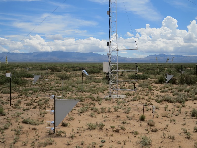
A 10 m meteorological tower is located in the center of rangeland sites, or at the downwind edge of cropland sites. The tower provides a platform to measure the wind velocity profile (6 heights), air temperature profile (3 heights), relative humidity, precipitation, and saltation particle counts (Sensit). The frequency and magnitude of sediment transport are measured using the saltation sensor and 27 rotating MWAC sediment samplers that measure sediment mass flux at four heights to 1 m above the soil surface. Three sampler masts are randomly located within each of the virtual grid cells, enabling the variance in the mass flux to be measured across the 1 ha sites. |
 Each Network site is instrumented with sensors and samplers to measure the controls on sediment transport, and sediment transport rates. The sites occupy a 1 ha area, divided into a virtual 3 x 3 grid that is used to stratify the location of sediment samplers and the soil survey.
Dust deposition traps are used to measure the vertical dust deposition flux and a vertical array of two DustTrak DRX samplers will be used to measure the fine sediment (dust) mass flux (PM10, PM2.5, PM1).
Comprehensive vegetation surveys are conducted four times per year, including the fractional vegetation cover by species, vegetation height, and vegetation canopy gap size distribution. The measurements are made along three intersecting 100 m transects.
 |
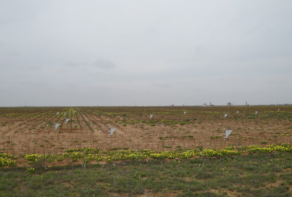 |
| Photos of Network sites at the Jornada Experimental Range, NM and Big Spring, TX. | |
Data Collection
Meteorological data are transferred by wireless network to a central database maintained at the Jornada Experimental Range in Las Cruces, NM.
Sediment sampler data (collected monthly), vegetation data (collected quarterly), site management records and time-lapse photographs of the sites are also maintained at the Jornada. All data are recorded and stored in standard format within the Database for Inventory, Monitoring and Assessment (DIMA), providing consistency and utility across the Network.